Overview
This document provides an overview of snow products of ASRv2. ASRv2 is a multi-agency, university-led regional reanalysis product that covers the Arctic. It is produced using high-resolution versions of the Polar Weather Forecast Model (PWRF) and the WRF-VAR and High Resolution Land Data Assimilation (HRLDAS) systems that have been optimized for the Arctic. The final version, which has 15 km horizontal resolution and spans 2000-2016 period, is available online through the NCAR's RDA.
Provider's contact information
ASRv2 is produced by Polar Meteorology Group, Byrd Polar & Climate Research Center, The Ohio State University and is available at NCAR CISL RDA.
RDA NCAR User support manager schuster@ucar.edu.
Licensing
Licence: This data are licensed under Creative Commons Attribution 4.0 International Licence (Licence agreement information can be found here)
Dataset citable as: National Center for Atmospheric Research/University Corporation for Atmospheric Research, and Polar Meterology Group/Byrd Polar and Climate Research Center/The Ohio State University. 2017. Arctic System Reanalysis version 2. Research Data Archive at the National Center for Atmospheric Research, Computational and Information Systems Laboratory. https://doi.org/10.5065/D6X9291B , https://rda.ucar.edu/datasets/ds631.1/
Bromwich, D., L. Bai, K. Hines, S. Wang, Z. Liu, H. Lin, Y. Kuo, and M. Barlage. 2012. Arctic System Reanalysis (ASR) Project. Research Data Archive at the National Center for Atmospheric Research, Computational and Information Systems Laboratory.
Variable name and units:
ASRv2 provides 2 products kind, analysis and forecast. The table below provide details for the snow-related products in ASRv2.
| Name (parameter) | Units | dataset |
|---|---|---|
| SNOW (SNOW WATER EQUIVALENT) | kg m-2 | ASRv2.0 2D surface analysis ASRv2.0 2D surface forecast |
| SNOWH (PHYSICAL SNOW DEPTH) | m | ASRv2.0 2D surface analysis |
| SNOWNC (ACCUMULATED 3 hour TOTAL GRID SCALE SNOW AND ICE) | mm | ASRv2.0 2D surface forecast |
| SNOALB (ANNUAL MAX SNOW ALBEDO IN FRACTION) | 0~1 | ASRv2.0 2D surface analysis ASRv2.0 2D surface forecast |
| SNOWC (FLAG INDICATING SNOW COVERAGE: 1 FOR SNOW COVER) | 0~1 | ASRv2.0 2D surface analysis ASRv2.0 2D surface forecast |
Spatial coverage and resolution:
Geographical Coverage: 15kmx15km (at 60 N) oriented 175 W (720x720 North Polar Stereographic).
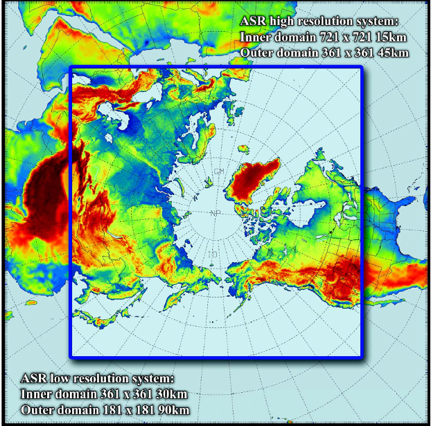
Figure 1. ASR domain (from http://polarmet.osu.edu/ASR/)
Temporal coverage and resolution:
ASRv2 snow products are available from 2000 to 2016 as 3-hourly subsets and monthly means.
Methodology
ASRv2 provides a high resolution description of the atmosphere-sea ice-land surface system of the Arctic. It is using the polar version of the Weather Research and Forecasting (WRF) model version 3.6.0. It uses the 3DVAR technique and the High Resolution Land Data Assimilation (HRLDAS) data assimilation systems that have been optimized for the Arctic. ASR employs the Noah Land Surface Model (LSM) with several improvements, including fractional sea ice within each grid cell and specified sea ice characteristics (e.g., thickness, snow cover over sea ice, albedo).
A full description of ASRv2 is presented in the Bulletin of the American Meteorological Society (PDF).
Observations data in ASRv2
The observations data used in ASRv2 (Figure 2) includes synoptic surface observations (black dots), METARs (purple plus signs), ship observations (royal blue dots), buoys (navy-blue dots), radiosondes (purple asterisks), global positioning system refractivity observations (red dots), wind profiler (yellow dots), aviation in-flight weather reports (green dots), QuikSCAT sea surface winds (orange dots), and satellite atmospheric motion vectors (aqua dots).
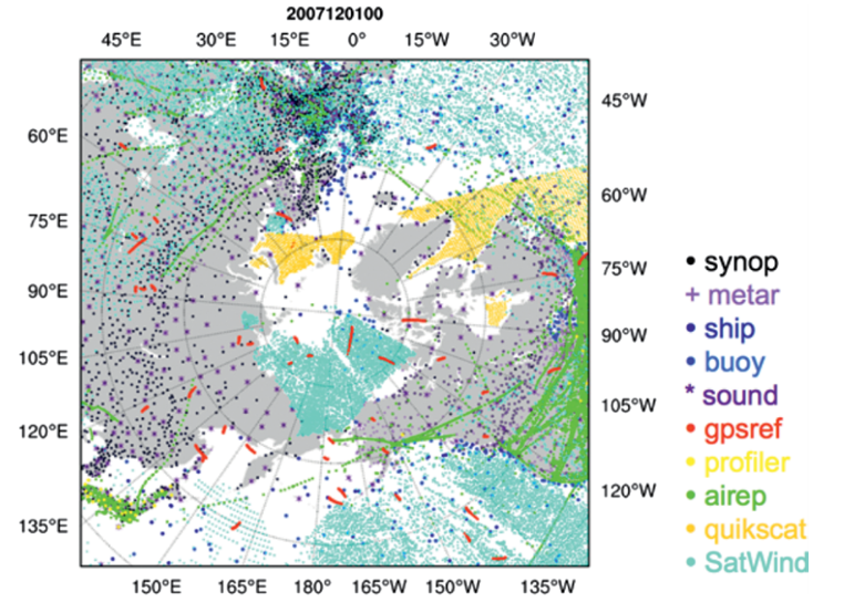
Figure 2. Sample distribution of observations
Sea ice fractions are prescribed from daily NSIDC SSMI/I microwave radiometer measurements for the Polar WRF model. These prescribed values include first-order seasonal variations for the Arctic Ocean that depend on latitude and time of year. A seasonal cycle is used for the sea ice albedo which varies annually based on melt/freeze dates from satellite observations. Snow cover and snow albedo are assimilated from the National Environmental Satellite, Data, and Information Service (NESDIS) observations and vary seasonally, again, to represent melting and freezing.
Information about the technical and scientific quality
New features in ASRv2 compared to ASRv1 are higher horizontal resolution, updated model physics including sub-grid scale cloud fraction interaction with radiation, and a dual outer loop routine for more accurate data assimilation.
The following document compares near-surface variables from ASRv1, ASRv2, and ERAI to observations from ∼4500 surface stations provided by the National Centers for Environmental Information (https://www.ncdc.noaa.gov/) for the period December 2006-November 2007: http://polarmet.osu.edu/ASR/asr_v2_table.pdf
Presently there are plans to update ASRv2. The updated version will use the latest version of WRF and WRFDA, a more advanced data assimilation procedure, implement Morrison microphysics with a specified variable aerosol concentration, change to Noah-MP land surface model, incorporate a thermodynamic sea ice model, and increase the horizontal resolution to at least 10 km with ~ 100 vertical levels. This version will be known as ASRv3. Plans are to conduct a reanalysis of the MOSAiC drift period (fall 2019 - fall 2020) and it will be available through NCAR.
Limitations and strengths for application in North Canada
The following notes are general observations provided at https://climatedataguide.ucar.edu/climate-data/arctic-system-reanalysis-asr :
Key Strengths: Excellent reproduction of near-surface and tropospheric variables
Key Limitations: A dry bias is still present during the cooler months in ASRv2.
References to documents describing the methodology or/and the dataset
Bromwich, D., Y.-H. Kuo, M. Serreze, J. Walsh, L.S. Bai, M. Barlage, K. Hines, and A, Slater, 2010: Arctic System Reanalysis: Call for community involvement. EOS Trans. AGU, 91, 13-14. https://doi.org/10.1029/2010EO020001
Online technical description: https://rda.ucar.edu/datasets/ds631.0/#!docs
Link to download the data and format of data:
Data Access:NCAR/RDA
ASRv2 is available in NetCDF formats
Link to download 3 hourly and monthly data on RDA:
3 hourly data surface analysis from 2000 to 2016
3 hourly data surface forecast from 2000 to 2016
ASR 15 km monthly means of analysis products
ASR 15 km monthly means of forecast products
Publications including dataset evaluation or comparison with other data in Canada
Bromwich, D.H., A.B. Wilson, L. Bai, G.W.K. Moore, and P. Bauer, 2016: A comparison of the regional Arctic System Reanalysis and the global ERA-Interim Reanalysis for the Arctic. Q. J. R. Meteorol. Soc., 142, 644-658. https://doi.org/10.1002/qj.2527
Bromwich, D.H., K.M. Hines, and L.-S. Bai, 2009: Development and testing of Polar WRF: 2. Arctic Ocean. J. Geophys. Res., 114, D08122. https://doi.org/10.1029/2008JD010300
Smirnova, J., and P. Golubkin, 2017: Comparing polar lows in atmospheric reanalyses: Arctic System Reanalysis versus ERA-Interim. Mon. Wea. Rev., 145, 2375-2383, https://doi.org/10.1175/MWR-D-16-0333.1
Avila-Diaz, A., D.H. Bromwich, A.B. Wilson, F. Justino, S.-H. Wang, 2021: Climate extremes across the North American Arctic in modern reanalyses. J. Climate, , 34, 2385–2410, https://doi.org/10.1175/JCLI-D-20-0093.1
Chanona, M., and S. Waterman, 2020: Temporal Variability of Internal Wave-Driven Mixing in Two Distinct Regions of the Arctic Ocean. J. Geophys. Res. Oceans, 125, https://doi.org/10.1029/2020JC016181
Edel, L., C. Claud, C. Genthon, C. Palerme, N. Wood, T. L’Ecuyer, and D. Bromwich, 2020: Arctic snowfall from CloudSat observations and reanalyses. J. Clim., 33, 2093-2109, https://doi.org/10.1175/JCLI-D-19-0105.1
Kaiser-Weiss, A.K., M. Borsche, D. Niermann, F. Kaspar, C. Lussana, F.A. Isotta, E. van den Besselaar, G. van der Schrier, and P. Undén, 2019: Added value of regional reanalyses for climatological applications. Environ. Res. Commun., 1, https://doi.org/10.1088/2515-7620/ab2ec3
Gutjahr, O., and G. Heinemann, 2018: A model-based comparison of extreme winds in the Arctic and around Greenland. Int. J. Clmatol., 38, 5272-5292, https://doi.org/10.1002/joc.5729
Rabatel, M., P. Rampal, A. Carrassi, L. Bertino, and C. K. Jones, 2018: Impact of rheology on probabilistic forecasts of sea ice trajectories: Application for search and rescue operations in the Arctic. Cryosphere, 12, 935-953, https://doi.org/10.5194/tc-12-935-2018
Kohnemann, S.H., G. Heinemann, D.H. Bromwich, and O. Gutjahr, 2017: Extreme warming in the Kara Sea and Barents Sea during the winter period 2000-16. J. Clim., 30, 8913-8927, https://doi.org/10.1175/JCLI-D-16-0693.1
Kolstad, E.W., 2017: Higher ocean wind speeds during marine cold air outbreaks. Quarterly J. Roy. Meteor. Soc., 143, 2084-2092, https://doi.org/10.1002/qj.3068
Rampal, P., S. Bouillon, E. Ólason, and M. Morlighem, 2016: neXtSIM: a new Lagrangian sea ice model. The Cryosphere, 10, 1055-1073, https://doi.org/10.5194/tc-10-1055-2016
Wang, F., W. Li, and S. Wang, 2016: Polar cyclone identification from 4D climate data in a knowledge-driven visualization system. Climate, 4, https://doi.org/10.3390/cli4030043